
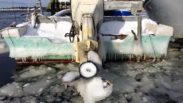
Temperatures to plummet near record lows
A wind chill advisory has been issued as feel-like temperatures could drop to -15 Friday morning
Temperatures will approach record lows Thursday night into Friday morning as an arctic blast heads toward the region.
Temperatures will begin plummeting late Thursday afternoon and continue …
This item is available in full to subscribers.
Please log in to continue |
Register to post eventsIf you'd like to post an event to our calendar, you can create a free account by clicking here. Note that free accounts do not have access to our subscriber-only content. |
Day pass subscribers
Are you a day pass subscriber who needs to log in? Click here to continue.
Temperatures to plummet near record lows
A wind chill advisory has been issued as feel-like temperatures could drop to -15 Friday morning
Temperatures will approach record lows Thursday night into Friday morning as an arctic blast heads toward the region.
Temperatures will begin plummeting late Thursday afternoon and continue dropping into the single digits overnight, according to the National Weather Service, which has issued a storm warning and high wind warning, as well as a wind chill advisory lasting through Friday morning.
Overnight lows are expected to bottom out around 8 degrees, approaching the Rhode Island record low of 6 degrees for this date. The single digits will continue into Friday morning before rising slightly into the teens Friday afternoon. Isolated rain and snow showers are expected into Friday morning before skies clear late morning.
Exacerbating the bitter cold is a heavy wind forecast through Thursday night, into Friday morning, with gusts possibly reaching 50 mph, the National Weather Service is forecasting. The wind chill will creat feel-like temperatures as low as -15 degrees by Friday morning, prompting the advisory.
"A wind chill advisory is issued when wind chill values of -15 to -24 degrees are likely for at least three hours," the National Weather Service reports. "Wind chill values below -20 can bring about frostbite in as little as 30 minutes. Outdoor exposure should be limited. If you must be outdoors, dress in layers and keep your hands and feet covered."
The bitter cold is expected to continue into Friday night, along with snow showers across the region into Saturday morning, when a warming trend will begin. Afternoon highs should reach the mid-40s Saturday, and continue to rise.
By Sunday afternoon, the frigid weather will be a memory, as temperatures soar near 60 degrees. Winter returns Monday, however, with expected temperatures in the low-20s.
Keywords
winter 2016, arctic blast


