
Bristol, Barrington, Warren team up with State to address Rt. 114 flooding
Multiple state entities and three local municipalities on the front lines of rising tides are teaming up to address a common problem that isn't going away any time soon: the flooding of Route 114.
This item is available in full to subscribers.
Please log in to continue |
Register to post eventsIf you'd like to post an event to our calendar, you can create a free account by clicking here. Note that free accounts do not have access to our subscriber-only content. |
Day pass subscribers
Are you a day pass subscriber who needs to log in? Click here to continue.
Bristol, Barrington, Warren team up with State to address Rt. 114 flooding


Multiple state entities and three local municipalities on the frontlines of rising tides are teaming up to address an issue you may have noticed has become much more common in recent years — the regular flooding of portions of Route 114 (the 46-mile north-to-south state thoroughfare known locally as Hope Street).
“Resilient Route 114” is a climate resiliency plan created in partnership between the Rhode Island Division of Statewide Planning, the Rhode Island Department of Transportation (RIDOT), the Rhode Island Public Transit Authority (RIPTA), and the Towns of Barrington, Warren, and Bristol, which strives to identify existing problem areas along the route and assess the best ways to prevent future issues caused by flooding.
“Even temporary disruptions to the use of this state-owned collector road can result in dramatic community impacts, ranging from disconnected neighborhoods for emergency services to the loss of economic production and damage to critical infrastructure,” reads the outline of the plan on the Statewide Planning website.
The plan specifically looks to target seven areas that have become a reoccurring problem for coastal flooding events — where the road is inundated with water not because of freak storm incidents, but rather from a combination of normal conditions like high tides, high winds, and regular rainfall.
The plan identifies seven AOVs (“areas of vulnerability”), which stretch from the Congregational Church in Barrington all the way south to the Walker’s Cove area near the Lobster Pot in Bristol, with two areas near the beginning of the Warren Bridge (near the so-called Warren Gateway) the lone AOV being investigated in Warren.
The project began in earnest last autumn, with a renewed focus on analyzing existing conditions and modeling what these areas will look like in the future as sea level rise and the frequency of extreme weather events continue to accelerate.
“If the effects of climate change on this major thoroughfare go unaddressed, rising waters and associated issues could sever a critical connection between Aquidneck Island and Providence as well as within the Towns of Bristol, Warren, and Barrington,” the project outline continues. “Bristol County residents rely heavily on Route 114 as one of their main routes to Providence and Kent Counties for commuting purposes. With its size and capacity as a State route, Route 114 is part of the Rhode Island Emergency Route Network, critical for maintaining the safety of residents before and during extreme weather events.”
What are the seven vulnerable areas?
AOV 1 lies at the intersection of Federal Road and Massasoit Avenue in Barrington near the Congregational Church.
AOV 2 is south of the first area where the creek from Prince Pond cuts behind the Presbyterian Church.
AOV 3 is downtown Barrington itself, which faces threats from the Barrington River to the east and flooding from Brickyard Pond in the west during severe flooding events.
AOVs 4 and 5 focus on the low-lying areas near the Warren and Barrington Bridges, one on either side in Barrington and one near the Warren Gateway in Warren.
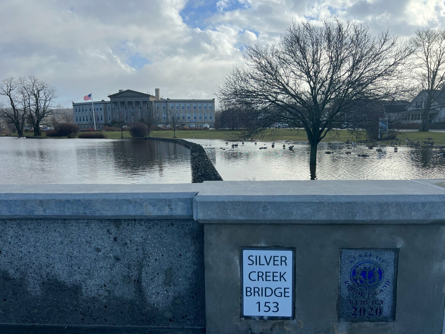
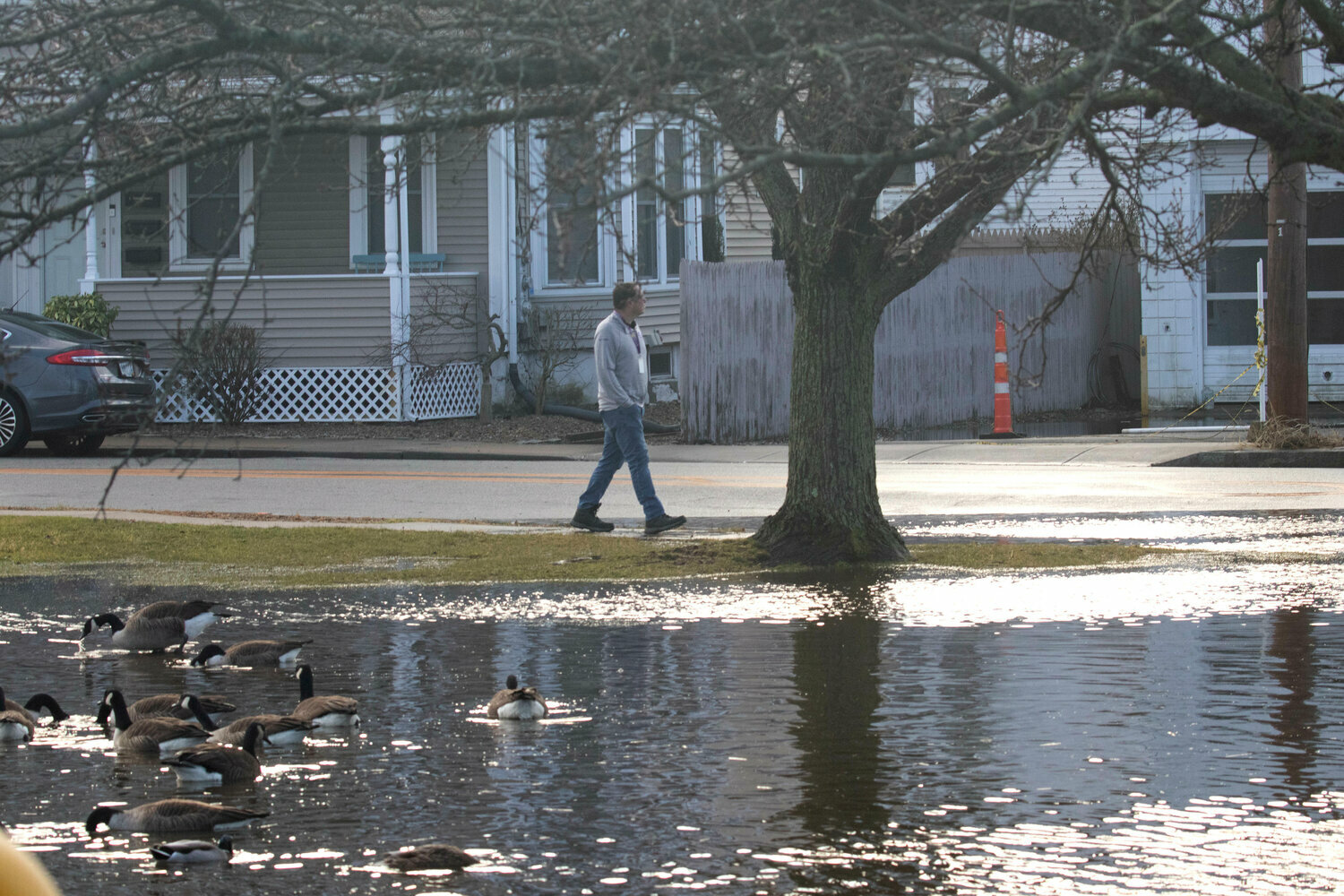
AOV 6 is near the Sip N’ Dip in Bristol, at the intersection of Hope and Washington Streets, where Silver Creek now regularly spills over and causes major traffic disruptions during rain events. Bristol’s Director of Community Development, Diane Williamson, agreed that this area provides a visceral example of the kind of impact coastal flooding can have on a community, recalling a picture she saw recently after a flooding event that completely inundated the area.
“There was so much water there were actually ducks floating in the road,” she said. “It’s so surreal to see that much water there and the frequency of events happening.”
AOV 7 is further south in Bristol, near the intersection of Hope and High Streets where The Lobster Pot sits.
So what’s the plan?
The project is now shifting from its information gathering phase into a public awareness phase. Two public meetings are scheduled for early June (one at Bristol Town Hall on Tuesday, June 4 and one at Barrington Town Hall on Thursday, June 6, times TBD, to be held both in person and virtually).
“The public's input is welcomed now and through January 2025, when the last of several public meetings/forums is scheduled,” said Warren Town Planner Herb Durfee through email. “While there will be public forums in each of the three communities, the ones in Warren will be held in October 2024 and January 2025.”
Durfee said that members of all three communities are welcome to attend any of the forums.
Arnold Robinson, Regional Planning Director for Fuss & O’Neill, the civil and environmental engineering firm and consultant team for the project, said that getting input from the people actually dealing with coastal flooding was an essential first step before trying to move towards any possible solutions.
“We don’t want to jump to a technical solution yet until we share with stakeholders in these communities about what are the realities of future flooding, what are the potential range of solutions that are out there, and what are their relative costs, and what is the cost-benefit analysis of those solutions?” he said in an interview on Monday. “It’s too easy to do climate planning at your desk looking at a model. You have to get out there and engage with stakeholders who own properties, who live in those areas, who own buildings and businesses and travel those roadways every day.”
As to what solutions could potentially be proposed, Robinson said it could vary depending on the location.
“I won’t say we know what the answers are yet. We know what some national best practices are, and we know what a range of some possible solutions are,” he said. “In some communities, there has been really well-systematized rerouting of traffic for big storm events…For some communities where they have low-lying roadways, they’re elevating those roadways, building higher bridges, elevating roadways a couple of feet and staying out of those more frequent flooding events.”
Towns not on the financial hook, but funding is TBD
Robinson said that federal dollars will likely be available through Statewide Planning to implement the eventual solutions that are agreed upon, and he confirmed that individual municipalities are not on the hook to provide a cash match, and are instead providing help in other ways.
“Municipalities are donating in-kind services to do all of the promotion for the public engagement…They're briefing their town councils and their planning boards on this because it's really going to be critical if we're going to have recommendations for implementation that stick, we need to have everybody engaged in the formulation of those recommendations,” he said. “This can't come out of left field as a, ‘Hey, here's the answer, you weren't involved in the process.’”
Roberta Groch, Assistant Chief of the Community Coordination Team for the Rhode Island Division of Statewide Planning, confirmed that communities can use in-kind work (like public works contributing work effort, and town planners donating their time to come up with implementation strategies) in order to satisfy the 20% match required to receive federal funding that they receive from the Federal Highway Administration.
She said that once solutions are identified and agreed upon, the state will be leveraging grant funding and federal allocations to bolster those solutions being implemented.
An issue that requires all hands on deck
Robinson said that he believes the public at large has begun to take the issues posed by climate change and rising tides more seriously, whether it’s the EMT driver who can’t get to a call on time because the road is flooded again, or the parent who is 20 minutes late to daycare to pick their child up for the same reason.
“I also don’t think that you can undervalue that there is a project management team which is composed of all three communities plus Statewide Planning, plus RIDOT, plus RIPTA,” he added. “It is not often that we get all of those entities in the same room for a common purpose related to resilience.”
Williamson agreed with the notion that taking a regional planning approach to the issue of climate change and rising tides causing flooding was a refreshing change of pace for community planning.
“Some of these conversations lead into other projects we might want to do in the future together,” she said. “I think we all get busy, and we’re all focused on our own tasks and our own towns and things we have to get done. But through his project we have time to connect and share thoughts. The interaction with the planners in other towns is really great. We don’t always get to do that.”
Groch agreed, indicating that the study could become a precedent for other resiliency efforts in the state.
“I haven’t seen any other studies like this in the state,” she said. “I personally hope this can be a model for other communities to not only work together, but start actually planning for what is going to be happening in the future before it happens, and to be planning for it and fundraising for it before it happens.”


