
NOAA makes progress on improving angler data
NOAA Fisheries and their Marine Recreational Information Program (MRIP) shared progress on two recreational fishing data collection initiatives , the Fishing Effort Survey study and the collaborative initiative to re-envision the partnership to collect data between NOAA, regional Councils, states and anglers.
The Fishing Effort Study is entering the eighth month of survey administration to determine differences in respondent recall and resulting recreational fishing effort estimates between the current Fishing Effort Survey design and a revised design. The initial pilot study showed NOAA Fisheries was overestimating recreational harvest levels by as much as 30 percent on many fish species.
The revised design being tested is producing improved data quality in alignment with the prior pilot study. The plan is to conclude data collection for the study by the end of the year and ultimately, in 2026, determine if and how a new design will be implemented in collaboration with partners.
NOAA also continues to re-evaluate their recreational fishing data collection partnership approaches. The goal is to transition to a new, collaboratively developed vision for the state-federal partnership in 2026 — one that better meets regionally specific data needs for sustainable, adaptive fisheries management. Anglers have long been vying for NOAA to set standards for electronic smartphone applications where anglers can help make MRIP data more robust.
Cable installation could impact boat and fishing for brief periods
If you power boat, sail or fish in the lower West Passage of Narragansett Bay you should know there will be cable laying construction going on from Quonset Point to Beavertail, from September to December of this year.
A safety workshop and information session by the Better Bay Alliance and Ørsted is scheduled for Thursday, Aug. 22, at 7 p.m. at the Cold Spring Community Center, 30 Beach St., North Kingstown. To register, visit Narragansett Bay Community Series: Revolution Wind Construction Update Tickets, Thu, Aug 22, 2024 at 7:00 PM | Eventbrite.
What cable is being laid?
Two submarine cables will be buried under the seafloor in the lower West Passage of Narragansett Bay as part of the Revolution Wind project. Cables will be laid side by side in two separate construction operations. The cables will be buried four to six feet under the sea floor, but when not possible to bury them due to crossing an existing cable or debris from the old Jamestown Bridge, matts will be laid down over the debris or existing cable with additional matts laid on top of the new cables. Post-construction surveys will take place to make sure cables are buried and protected properly.
What boating or fishing could construction impact?
Mariners transiting or fishing (particularly for tautog) in the lower West Passage could be impacted. Areas impacted include the General Rock ledge area, rock clusters between Wickford and Fox Island, fishing at Plum Beach Light and over debris from the old Jamestown Bridge. The cable-laying barge, support tugs and survey vessels are mobile and continuously moving, so best to check the Mariner Brief daily or look at a Marine Traffic AIS Application.
Areas I believe that will not impact tautog fishing include mussel beds along the west side of Jamestown and south, fishing close to Beavertail Point, in front of Bonnet Cliffs, the Whale Rock area and rock clusters off Narragansett at Narrow River.
Are there safety and research/monitoring plans in place for the project?
David Lussier, president of the Better Bay Alliance (BBA), a non-profit organization dedicated to enhancing boating safety in Rhode Island waters, said: “The Better Bay Alliance is not in any partnership with Ørsted, and we are not an endorsing or supporting organization, but rather simply an interested party that wants the boating public to fully understand what their plans are so that boating safety in our waters remains a priority for all users of our waterways.” The Better Bay Alliance has developed LIVE CHART, an online program on their website, which illustrates specific areas and schedules for the cable laying project, so stakeholders remain informed. LIVE CHART is free and easily accessible at www.betterbayalliance.org .
John Mansolillo, Marine Affairs manager for Ørsted, said: “Our major concern is mariner safety, and we aim to alert mariners as to where and when we are working, as well as follow mandated construction safety guidelines for the project. This includes a safety zone around construction vessels from the Coast Guard.”
Highlights of the Project Safety plan include updates on Live Chart from the Better Bay Alliance, project updates weekly via posted and emailed Mariner Briefings, the use of Automated Identification Systems via VHF radio, Securite calls when appropriate, scout and safety vessel in project area, and properly lit construction vessels.
Where’s the bite?
Freshwater: Anglers have been catching fish at cooler times, early morning, sunset or at night. With cooler weather, anglers are hopeful that the large and small mouth bass bite will do nothing but get better.
Striped bass, bluefish, bonito
Steven Orefice of Watch Hill Outfitters, Westerly, said: “Striped bass fishing on Westerly reefs and at the Southwest Ledge at Block Island has been hit or miss. But things have improved. This week we had some nice bluefish on the surface too.”
“This cooler weather will be great for striped bass fishing out in front and in the bay, where we have Atlantic menhaden schools in greater abundance now. The Bonito bite this week was good out in front of Newport,” said Brian Combra of Sam’s Bait & Tackle, Middletown.
Tom Olson of Ponaug Bait & Tackle, Warwick, said, “The striped bass and bluefish bite in the bay is very slow, but we have some kayak customers that are still doing well fishing the Newport Bridge area and out in front on Brenton Reef in Newport.”
Fluke (summer flounder),
black sea bass and scup
Brian Combra of Sam’s said, “The fluke bite has picked up in the Newport Bridge area, with anglers catching keepers.”
“Fluke fishing is still slow with shorts being caught with an occasional keeper. Those catching keepers are in lower water, the 30- to 40-foot range. We do have more keeper black sea bass being caught,” said Steven Orefice of Watch Hill Outfitters.
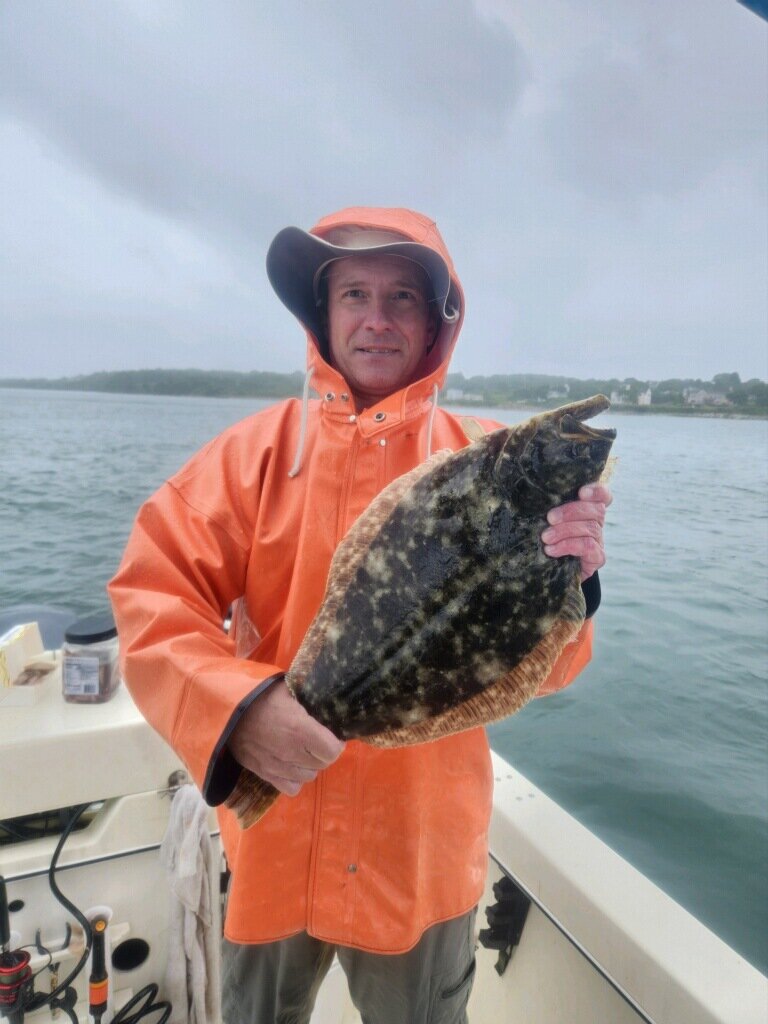
Kevin Fetzer of East Greenwich and his business and fishing partner Joe Klinger hooked up with 21” and 22” summer flounder in the West Passage near Austin Hollow.
Bluefin tuna
“Tuna reports last week were good. The bite is coming from jig and troll. With the weather window this week looking promising, we hope the bite holds up so more boats can get out to try their luck,” said Declan O’Donnell of Breachway Bait & Tackle.
Dave Monti holds a head captain’s license and charter fishing license. He serves on a variety of boards and commissions and has a consulting business focusing on clean oceans, habitat preservation, conservation, renewable energy, and fisheries related issues and clients. Forward fishing news and photos to dmontifish@verison.net or visit www.noflukefishing.com.


