
Former Kickemuit Reservoir derided as 'mud put' following removal of dams
Some who have driven by the former Kickemuit Reservoir have been shocked by what they see - but looks can also be deceiving.
This item is available in full to subscribers.
Please log in to continue |
Register to post eventsIf you'd like to post an event to our calendar, you can create a free account by clicking here. Note that free accounts do not have access to our subscriber-only content. |
Day pass subscribers
Are you a day pass subscriber who needs to log in? Click here to continue.
Former Kickemuit Reservoir derided as 'mud put' following removal of dams

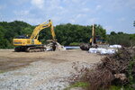
Back in March, work to remove two dams — one originally constructed in 1883 and another added in 1961 that for over a century contained a stretch of fresh drinking water from Schoolhouse Road to Child Street known as the Warren Reservoir — was finally completed after years of preparation.
In the months since, people driving by the former reservoir on both roads have certainly noticed a much different sight than one they had grown used to seeing. One comment, posted on a thread in the “You’re probably from Warren, RI if…” Facebook group, summed up one such impression quite effectively.
“THEY DID A TERRIBLE injustice,” the comment reads. “It’s an awful mud pit! Whoever made that decision [ought] to be fired! Drive by and look at it. Its [sic] speaks for itself.”
The Times-Gazette caught up with some of the people who had a hand in making the decision, to see if they have heard similar criticism, to further explain what the goals of the project were in the first place, and to get their take on whether the result has been what they anticipated.
Why the dams were removed
The reservoir had not been used for drinking water since 2011, when it was relegated solely as a source of emergency fire suppression for the surrounding area. It was fully abandoned even from that use in 2019. The Bristol County Water Authority had long since secured a new primary water source from Providence Water’s Scituate Reservoir via the East Bay Pipeline in 1998.
The water authority, as a result, began looking into the possibility of removing the dams in 2013, as they claimed their aging water treatment plant was unable to adequately treat the water, which was already becoming brackish as a result of inundation of the southern dam during high tide events.
“There was no need to continue maintaining the dams,” said Steven Coutu, Executive Director of the Bristol County Water Authority. “They were built in the first place as a water supply and we were no longer using it as a water supply, so it makes no business sense to continue to maintain dams that are no longer in need.”
Wenley Ferguson, Director of Habitat Restoration for Save The Bay, has been the leading environmental expert overseeing the project from the very beginning, all the way back in 2015, following a 2013 finding from the Rhode Island Department of Health’s “Safe Water RI” report that indicated the reservoir was “critically vulnerable” to three climate change factors: sea level rise, coastal flooding, and hurricanes.
“This site had some of the highest levels of nutrients in the state,” Ferguson said in a recent interview. “It was often hyper-eutrophic, meaning very high levels of nutrients. Very low oxygen levels, even though it’s quite shallow, and the water quality was very poor. There were fish that did survive in it but it was not a healthy habitat.”
Ferguson said that widespread freshwater plant die off at the water line and the total disappearance of freshwater species that had traditionally been seen at the reservoir in healthier times, such as painted turtles, and the thriving of creatures that prefer brackish water, such as snapping turtles and blue crabs, were all clear indicators that the reservoir’s waters were turning irrevocably salty.
There were other visible signs of the water body’s poor health, as well.
“If you went by the Kicki this time of year…before they started this project, right now that thing would be as green as anybody’s lawn because it would be completely choked with algae, which just kills all the oxygen in the body of water it covers,” said Butch Lombardi, who sits on the Town’s Conservation Commission. “So the fish and turtles were being starved of oxygen in the state it was in. It was not a healthy body of water.”
Has the goal of the project been realized?
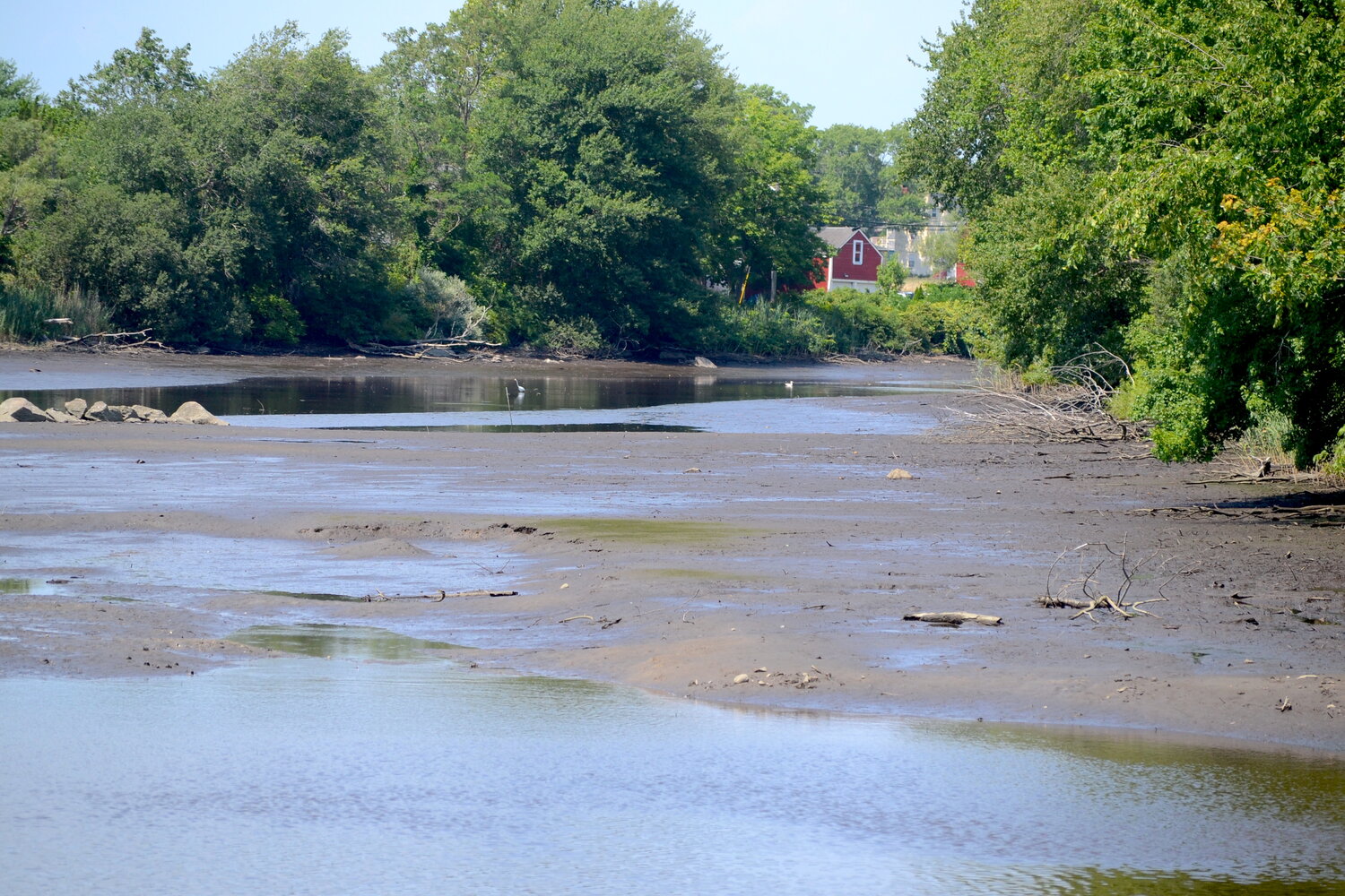
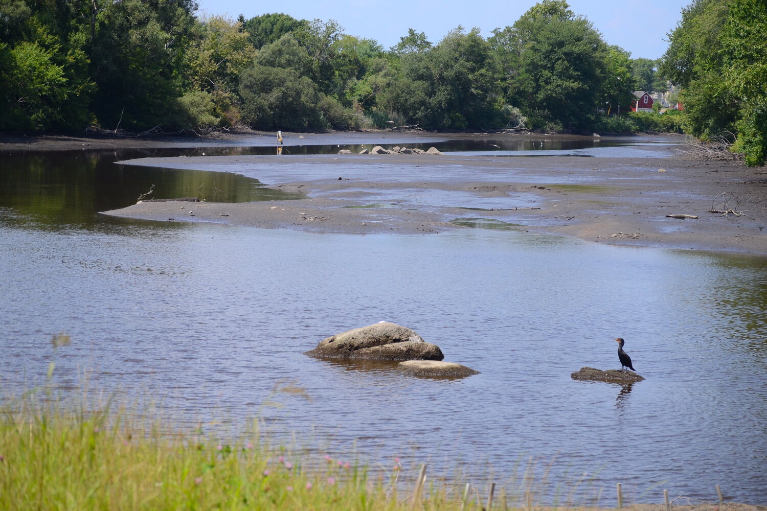
By removing the dams, Ferguson said that the area would begin reverting to the state it was in prior to the first dam being constructed in the late 19th century; a tidal saltwater estuary that experiences two low tides and two high tides.
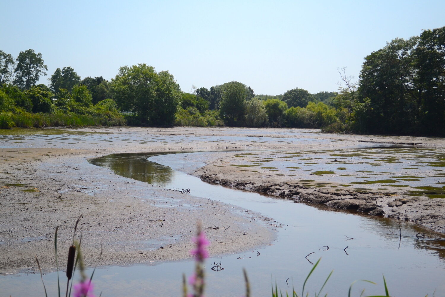
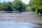
When asked about some of the critical responses to the appearance of the lower portion of the former reservoir, which can be seen best from Child Street heading towards Kickemuit Middle School, Ferguson said that the muddy appearance of the area during low tides is the result of decades of impoundment of the water while it was dammed.
“Any time you hold water on a marsh, the marsh sinks. Standing water on the marsh causes vegetation to die off and then there’s no vegetation and roots to hold the peat, and the entire marsh surface begins to sink,” she said. “Because that water had been on the marsh for so many years, where there had been salt marsh prior to humans installing a dam, now that is lower in elevation. So instead of supporting salt marsh vegetation along those banks where the creek kind of meanders up that you can see from Child Street, now it’s mud flat.”
Ferguson was at work earlier this summer planting spartina alterniflora (also known as salt marsh cordgrass) along portions of the newly exposed banks of the lower river. Over time, the hope is that the vegetation will reclaim the area and reduce the drastic appearance of the mud flat.
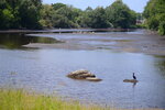
According to Ferguson, numerous ecological goals of the project are already showing signs of success. Ospreys are now seen hunting in the lower area, indicative that the water quality has cleared up enough from its daily flushing for them to see their prey. She also mentioned seeing egrets and red-breasted mergansers, a type of duck that frequents saltwater systems looking for food.
In the former upper impoundment area, which was locked behind the earthen berm constructed in 1961, Ferguson said they are already seeing some regrowth of saltwater vegetation, and additional plantings are planned in the coming months. That area of forested saltwater marsh is unique and rare in Rhode Island, she said, and will go a long way towards increasing storm capacity in the area to prevent flooding.
“When you look at sea level rise maps and where marshes have the ability to migrate into the future, those woodlands are places where we will have future salt marsh,” she said.
Overall, Ferguson said that while the appearance might seem drastic to some while seeing it at low tide, the overall goals of the project are being realized.
“We’re watching it recover,” she said. “It’s not going to be the same as it was before the dams were installed but it’s going to be healthier water-quality-wise, healthier habitat-wise, as well as more resilient to these more intense storms.”
For Lombardi, who said he was initially skeptical about the project, it was the reputation of Save The Bay as the state’s leading advocacy group for the environmental health of Rhode Island’s most treasured natural resources that eventually nudged him towards trusting the process.
“Save The Bay was in favor of this from the get go, and if you look at their track record, they have been instrumental into getting the Bay to where it is now,” he said.
What about the protected land?
Another comment seen on the same Facebook thread mentioned earlier in this story indicated concern that with the dams removed and the freshwater body officially removed, it now opens up the area surrounding the reservoir to development.
Coutu said in a recent interview that development of land they own surrounding the reservoir was not something that has been discussed or planned.
“A lot of the land is wetlands, too. None of the discussions I’ve had with the board up to this point has had anything to do with looking to sell any property,” he said. “We’ve been focused on getting the project done.”
Coutu said that the board had already begun some preliminary discussions with the Conservation Commission about opening up the area to more recreational uses since the stringent freshwater restrictions preventing boating and swimming are no longer required. To date, however, there’s no definitive plan.
“We’ll look at it from that lens, whether it’s opened up as open space, what kind of liability we have if we’re doing that, we have to consider those things too,” Coutu said. “It will be good to find locations to provide more public access to the river.”
Coutu also mentioned that the work to remove the dam was done using up to $4 million in federal grant funding from various sources, and has not required any funding on the backs of ratepayers.
“They’re close to wrapping things up, hopefully towards the end of this month or so,” he said. “From our perspective, as far as the contract goes, it’s gone well.”


